For SAFETY and trail preservation please no bikes between Berkshire and Hampstead. Use indicated route ...THX! NOTE: Some parts of this trail may be closed due to recent rains.
eyJtYXBfb3B0aW9ucyI6eyJjZW50ZXJfbGF0IjoiMzQuMTkyMjU0MSIsImNlbnRlcl9sbmciOiItMTE4LjIxMDU0MSIsInpvb20iOjE1LCJtYXBfdHlwZV9pZCI6IlNBVEVMTElURSIsImNlbnRlcl9ieV9uZWFyZXN0Ijp0cnVlLCJmaXRfYm91bmRzIjp0cnVlLCJjZW50ZXJfY2lyY2xlX2ZpbGxjb2xvciI6IiM4Q0FFRjIiLCJjZW50ZXJfY2lyY2xlX2ZpbGxvcGFjaXR5IjoiLjUiLCJjZW50ZXJfY2lyY2xlX3N0cm9rZWNvbG9yIjoiIzhDQUVGMiIsImNlbnRlcl9jaXJjbGVfc3Ryb2tlb3BhY2l0eSI6Ii41IiwiY2VudGVyX2NpcmNsZV9yYWRpdXMiOiI1Iiwic2hvd19jZW50ZXJfY2lyY2xlIjpmYWxzZSwic2hvd19jZW50ZXJfbWFya2VyIjpmYWxzZSwiY2VudGVyX21hcmtlcl9pY29uIjoiaHR0cDovL3d3dy5sY2Z0cmFpbHMub3JnL3dwLWNvbnRlbnQvcGx1Z2lucy93cC1nb29nbGUtbWFwLWdvbGQvYXNzZXRzL2ltYWdlcy8vZGVmYXVsdF9tYXJrZXIucG5nIiwiY2VudGVyX2NpcmNsZV9zdHJva2V3ZWlnaHQiOiIxIiwiZHJhZ2dhYmxlIjp0cnVlLCJnZXN0dXJlIjoiYXV0byIsIm1hcmtlcl9kZWZhdWx0X2ljb24iOiJodHRwczovL3d3dy5sY2Z0cmFpbHMub3JnL3dwLWNvbnRlbnQvcGx1Z2lucy93cC1nb29nbGUtbWFwLWdvbGQvYXNzZXRzL2ltYWdlcy9pY29ucy9nb29nbGUtbWFwLWRlZmF1bHQtaWNvbi5wbmciLCJpbmZvd2luZG93X3NldHRpbmciOiI8ZGl2IGNsYXNzPVwiZmMtaXRlbS1ib3ggZmMtaXRlbS1uby1wYWRkaW5nIFwiPlxuXHR7bWFya2VyX2ltYWdlfTwvcD5cbjxkaXYgY2xhc3M9XCJmYy1pdGVtY29udGVudC1wYWRkaW5nXCI+XG48ZGl2IGNsYXNzPVwiZmMtaXRlbWNvbnRlbnQtcGFkZGluZyBmYy1pdGVtLW5vLXBhZGRpbmdcIj5cbjxkaXYgY2xhc3M9XCJmYy1pdGVtLXRpdGxlIGZjLWl0ZW0tcHJpbWFyeS10ZXh0LWNvbG9yIGZjLWl0ZW0tdG9wLXNwYWNlXCI+e21hcmtlcl90aXRsZX08L2Rpdj5cbjxkaXYgY2xhc3M9XCJmYy1pdGVtLWNvbnRlbnQgZmMtaXRlbS1ib2R5LXRleHQtY29sb3JcIj57bWFya2VyX2FkZHJlc3N9PC9kaXY+XG48L3A+PC9kaXY+XG48L3A+PC9kaXY+XG48ZGl2IGNsYXNzPVwiZmMtY2xlYXJcIj48L2Rpdj5cbjwvZGl2PlxuIiwiaW5mb3dpbmRvd19nZW90YWdzX3NldHRpbmciOiI8ZGl2IGNsYXNzPVwiZmMtbWFpblwiPjxkaXYgY2xhc3M9XCJmYy1pdGVtLXRpdGxlXCI+e3Bvc3RfdGl0bGV9IDxzcGFuIGNsYXNzPVwiZmMtYmFkZ2UgaW5mb1wiPntwb3N0X2NhdGVnb3JpZXN9PC9zcGFuPjwvZGl2PiA8ZGl2IGNsYXNzPVwiZmMtaXRlbS1mZWF0dXJlZF9pbWFnZVwiPntwb3N0X2ZlYXR1cmVkX2ltYWdlfSA8L2Rpdj57cG9zdF9leGNlcnB0fTxhZGRyZXNzPjxiPkFkZHJlc3MgOiA8L2I+e21hcmtlcl9hZGRyZXNzfTwvYWRkcmVzcz48YSB0YXJnZXQ9XCJfYmxhbmtcIiAgY2xhc3M9XCJmYy1idG4gZmMtYnRuLXNtYWxsIGZjLWJ0bi1yZWRcIiBocmVmPVwie3Bvc3RfbGlua31cIj5SZWFkIE1vcmUuLi48L2E+PC9kaXY+IiwiaW5mb3dpbmRvd19za2luIjp7Im5hbWUiOiJhYXJlIiwidHlwZSI6ImluZm93aW5kb3ciLCJzb3VyY2Vjb2RlIjoiPGRpdiBjbGFzcz1cImZjLWl0ZW0tYm94IGZjLWl0ZW0tbm8tcGFkZGluZyBcIj5cclxuXHR7bWFya2VyX2ltYWdlfVxyXG4gICAgPGRpdiBjbGFzcz1cImZjLWl0ZW1jb250ZW50LXBhZGRpbmdcIj5cclxuICAgIFx0PGRpdiBjbGFzcz1cImZjLWl0ZW1jb250ZW50LXBhZGRpbmcgZmMtaXRlbS1uby1wYWRkaW5nXCI+XHJcbiAgICAgICAgXHQ8ZGl2IGNsYXNzPVwiZmMtaXRlbS10aXRsZSBmYy1pdGVtLXByaW1hcnktdGV4dC1jb2xvciBmYy1pdGVtLXRvcC1zcGFjZVwiPnttYXJrZXJfdGl0bGV9PC9kaXY+XHJcbiAgICAgICAgICAgIDxkaXYgY2xhc3M9XCJmYy1pdGVtLWNvbnRlbnQgZmMtaXRlbS1ib2R5LXRleHQtY29sb3JcIj57bWFya2VyX2FkZHJlc3N9PC9kaXY+XHJcbiAgICAgICAgIDwvZGl2PlxyXG4gICAgPC9kaXY+XHJcbiAgICA8ZGl2IGNsYXNzPVwiZmMtY2xlYXJcIj48L2Rpdj4gICAgXHJcbjwvZGl2PiJ9LCJpbmZvd2luZG93X3Bvc3Rfc2tpbiI6eyJuYW1lIjoiZGVmYXVsdCIsInR5cGUiOiJwb3N0Iiwic291cmNlY29kZSI6IjxkaXYgY2xhc3M9XCJmYy1tYWluXCI+PGRpdiBjbGFzcz1cImZjLWl0ZW0tdGl0bGVcIj57cG9zdF90aXRsZX0gPHNwYW4gY2xhc3M9XCJmYy1iYWRnZSBpbmZvXCI+e3Bvc3RfY2F0ZWdvcmllc308L3NwYW4+PC9kaXY+IDxkaXYgY2xhc3M9XCJmYy1pdGVtLWZlYXR1cmVkX2ltYWdlXCI+e3Bvc3RfZmVhdHVyZWRfaW1hZ2V9IDwvZGl2Pntwb3N0X2V4Y2VycHR9PGFkZHJlc3M+PGI+QWRkcmVzcyA6IDwvYj57bWFya2VyX2FkZHJlc3N9PC9hZGRyZXNzPjxhIHRhcmdldD1cIl9ibGFua1wiICBjbGFzcz1cImZjLWJ0biBmYy1idG4tc21hbGwgZmMtYnRuLXJlZFwiIGhyZWY9XCJ7cG9zdF9saW5rfVwiPlJlYWQgTW9yZS4uLjwvYT48L2Rpdj4ifSwiaW5mb3dpbmRvd19kcm9wX2FuaW1hdGlvbiI6ZmFsc2UsImNsb3NlX2luZm93aW5kb3dfb25fbWFwX2NsaWNrIjpmYWxzZSwiZGVmYXVsdF9pbmZvd2luZG93X29wZW4iOmZhbHNlLCJpbmZvd2luZG93X29wZW5fZXZlbnQiOiJjbGljayIsImlzX21vYmlsZSI6ZmFsc2UsImluZm93aW5kb3dfZmlsdGVyX29ubHkiOmZhbHNlLCJpbmZvd2luZG93X2NsaWNrX2NoYW5nZV96b29tIjowLCJpbmZvd2luZG93X2NsaWNrX2NoYW5nZV9jZW50ZXIiOmZhbHNlLCJmdWxsX3NjcmVlbl9jb250cm9sIjp0cnVlLCJzZWFyY2hfY29udHJvbCI6dHJ1ZSwiem9vbV9jb250cm9sIjp0cnVlLCJtYXBfdHlwZV9jb250cm9sIjp0cnVlLCJzdHJlZXRfdmlld19jb250cm9sIjp0cnVlLCJsb2NhdGVtZV9jb250cm9sIjp0cnVlLCJtb2JpbGVfc3BlY2lmaWMiOmZhbHNlLCJ6b29tX21vYmlsZSI6NSwiZHJhZ2dhYmxlX21vYmlsZSI6dHJ1ZSwic2Nyb2xsX3doZWVsX21vYmlsZSI6dHJ1ZSwiZnVsbF9zY3JlZW5fY29udHJvbF9wb3NpdGlvbiI6IlRPUF9SSUdIVCIsInNlYXJjaF9jb250cm9sX3Bvc2l0aW9uIjoiVE9QX0xFRlQiLCJsb2NhdGVtZV9jb250cm9sX3Bvc2l0aW9uIjoiVE9QX0xFRlQiLCJ6b29tX2NvbnRyb2xfcG9zaXRpb24iOiJUT1BfTEVGVCIsIm1hcF90eXBlX2NvbnRyb2xfcG9zaXRpb24iOiJUT1BfUklHSFQiLCJtYXBfdHlwZV9jb250cm9sX3N0eWxlIjoiSE9SSVpPTlRBTF9CQVIiLCJzdHJlZXRfdmlld19jb250cm9sX3Bvc2l0aW9uIjoiVE9QX0xFRlQiLCJtYXBfY29udHJvbCI6ZmFsc2UsInNjcmVlbnMiOnsic21hcnRwaG9uZXMiOnsibWFwX3pvb21fbGV2ZWxfbW9iaWxlIjoiNSJ9LCJpcGFkcyI6eyJtYXBfem9vbV9sZXZlbF9tb2JpbGUiOiI1In0sImxhcmdlLXNjcmVlbnMiOnsibWFwX3pvb21fbGV2ZWxfbW9iaWxlIjoiNSJ9fSwibWFwX2luZm93aW5kb3dfY3VzdG9taXNhdGlvbnMiOmZhbHNlLCJpbmZvd2luZG93X3dpZHRoIjoiMTAwJSIsImluZm93aW5kb3dfYm9yZGVyX2NvbG9yIjoicmdiYSgwLCAwLCAwLCAwLjA5ODAzOTIpIiwiaW5mb3dpbmRvd19iZ19jb2xvciI6IiNmZmYiLCJzaG93X2luZm93aW5kb3dfaGVhZGVyIjpmYWxzZSwibWluX3pvb20iOiIxMCIsIm1heF96b29tIjoiMTkiLCJ6b29tX2xldmVsX2FmdGVyX3NlYXJjaCI6MTAsInVybF9maWx0ZXJzIjpmYWxzZSwiZG91YmxlY2xpY2t6b29tIjpmYWxzZSwiY3VycmVudF9wb3N0X29ubHkiOmZhbHNlLCJib3VuZF9tYXBfYWZ0ZXJfZmlsdGVyIjpmYWxzZSwiZGlzcGxheV9yZXNldF9idXR0b24iOmZhbHNlLCJtYXBfcmVzZXRfYnV0dG9uX3RleHQiOiJSZXNldCIsImhlaWdodCI6IjU1MCJ9LCJwbGFjZXMiOlt7ImlkIjoiMTIiLCJ0aXRsZSI6IkZsaW50IENhbnlvbiBUcmFpbCAtIFNvdXRoIGFuZCBXZXN0IEFjY2VzcyBQb2ludCIsImFkZHJlc3MiOiI0MTcxIENoZXJyeSBDYW55b24gTXR3eSwgTGEgQ2FcdTAwZjFhZGEgRmxpbnRyaWRnZSwgQ0EgOTEwMTEsIFVTQSIsInNvdXJjZSI6Im1hbnVhbCIsImxvY2F0aW9uIjp7Imljb24iOiJodHRwczovL3d3dy5sY2Z0cmFpbHMub3JnL3dwLWNvbnRlbnQvcGx1Z2lucy93cC1nb29nbGUtbWFwLWdvbGQvYXNzZXRzL2ltYWdlcy9pY29ucy9oaWtpbmctdG91cmlzbS5wbmciLCJsYXQiOiIzNC4xOTIyNTQxIiwibG5nIjoiLTExOC4yMTA1NDEiLCJjaXR5IjoiTGEgQ2FcdTAwZjFhZGEgRmxpbnRyaWRnZSIsInN0YXRlIjoiQ2FsaWZvcm5pYSIsImNvdW50cnkiOiJVbml0ZWQgU3RhdGVzIiwib25jbGlja19hY3Rpb24iOiJtYXJrZXIiLCJvcGVuX25ld190YWIiOiJ5ZXMiLCJwb3N0YWxfY29kZSI6IjkxMDExIiwiZHJhZ2dhYmxlIjpmYWxzZSwiaW5mb3dpbmRvd19kZWZhdWx0X29wZW4iOmZhbHNlLCJhbmltYXRpb24iOiJCT1VOQ0UiLCJpbmZvd2luZG93X2Rpc2FibGUiOnRydWUsInpvb20iOjUsImV4dHJhX2ZpZWxkcyI6eyJsaXN0b3JkZXIiOjB9fSwiY2F0ZWdvcmllcyI6W3siaWQiOiI0IiwibmFtZSI6Ikhpa2UiLCJ0eXBlIjoiY2F0ZWdvcnkiLCJleHRlbnNpb25fZmllbGRzIjp7ImNhdF9vcmRlciI6IjAifSwiaWNvbiI6Imh0dHBzOi8vd3d3LmxjZnRyYWlscy5vcmcvd3AtY29udGVudC9wbHVnaW5zL3dwLWdvb2dsZS1tYXAtZ29sZC9hc3NldHMvaW1hZ2VzL2ljb25zL2hpa2luZy10b3VyaXNtLnBuZyJ9XX0seyJpZCI6IjEzIiwidGl0bGUiOiJGbGludCBDYW55b24gVHJhaWwgLSBOb3J0aCBFYXN0IEFjY2VzcyBQb2ludCIsImFkZHJlc3MiOiJPYWsgR3JvdmUgRHIsIExhIENhXHUwMGYxYWRhIEZsaW50cmlkZ2UsIENBIDkxMDExLCBVU0EiLCJzb3VyY2UiOiJtYW51YWwiLCJsb2NhdGlvbiI6eyJpY29uIjoiaHR0cHM6Ly93d3cubGNmdHJhaWxzLm9yZy93cC1jb250ZW50L3BsdWdpbnMvd3AtZ29vZ2xlLW1hcC1nb2xkL2Fzc2V0cy9pbWFnZXMvaWNvbnMvaGlraW5nLXRvdXJpc20ucG5nIiwibGF0IjoiMzQuMTg1OTc5MzA0NzAwMzEiLCJsbmciOiItMTE4LjE3NzI1NjM5MDY2ODUiLCJjaXR5IjoiTGEgQ2FcdTAwZjFhZGEgRmxpbnRyaWRnZSIsInN0YXRlIjoiQ2FsaWZvcm5pYSIsImNvdW50cnkiOiJVbml0ZWQgU3RhdGVzIiwib25jbGlja19hY3Rpb24iOiJtYXJrZXIiLCJvcGVuX25ld190YWIiOiJ5ZXMiLCJwb3N0YWxfY29kZSI6IjkxMDExIiwiZHJhZ2dhYmxlIjpmYWxzZSwiaW5mb3dpbmRvd19kZWZhdWx0X29wZW4iOmZhbHNlLCJhbmltYXRpb24iOiJCT1VOQ0UiLCJpbmZvd2luZG93X2Rpc2FibGUiOnRydWUsInpvb20iOjUsImV4dHJhX2ZpZWxkcyI6eyJsaXN0b3JkZXIiOjB9fSwiY2F0ZWdvcmllcyI6W3siaWQiOiI0IiwibmFtZSI6Ikhpa2UiLCJ0eXBlIjoiY2F0ZWdvcnkiLCJleHRlbnNpb25fZmllbGRzIjp7ImNhdF9vcmRlciI6IjAifSwiaWNvbiI6Imh0dHBzOi8vd3d3LmxjZnRyYWlscy5vcmcvd3AtY29udGVudC9wbHVnaW5zL3dwLWdvb2dsZS1tYXAtZ29sZC9hc3NldHMvaW1hZ2VzL2ljb25zL2hpa2luZy10b3VyaXNtLnBuZyJ9XX0seyJpZCI6IjQ3IiwidGl0bGUiOiJGbGludCBDYW55b24gVHJhaWwgLSBOb3J0aCBCaWtlIEJ5cGFzcyIsImFkZHJlc3MiOiI0MTcwLTQxNzQgSGFtcHN0ZWFkIFJkLCBMYSBDYVx1MDBmMWFkYSBGbGludHJpZGdlLCBDQSA5MTAxMSwgVVNBIiwic291cmNlIjoibWFudWFsIiwibG9jYXRpb24iOnsiaWNvbiI6Imh0dHBzOi8vd3d3LmxjZnRyYWlscy5vcmcvd3AtY29udGVudC9wbHVnaW5zL3dwLWdvb2dsZS1tYXAtZ29sZC9hc3NldHMvaW1hZ2VzL2ljb25zL2N5Y2xpbmcucG5nIiwibGF0IjoiMzQuMTkzOTA3MTcwOTMxNjUiLCJsbmciOiItMTE4LjIwMzI5OTEwMTg1MjQiLCJjaXR5IjoiTGEgQ2FcdTAwZjFhZGEgRmxpbnRyaWRnZSIsInN0YXRlIjoiQ2FsaWZvcm5pYSIsImNvdW50cnkiOiJVbml0ZWQgU3RhdGVzIiwib25jbGlja19hY3Rpb24iOiJtYXJrZXIiLCJvcGVuX25ld190YWIiOiJ5ZXMiLCJwb3N0YWxfY29kZSI6IjkxMDExIiwiZHJhZ2dhYmxlIjpmYWxzZSwiaW5mb3dpbmRvd19kZWZhdWx0X29wZW4iOmZhbHNlLCJhbmltYXRpb24iOiJCT1VOQ0UiLCJpbmZvd2luZG93X2Rpc2FibGUiOnRydWUsInpvb20iOjUsImV4dHJhX2ZpZWxkcyI6eyJsaXN0b3JkZXIiOjB9fSwiY2F0ZWdvcmllcyI6W3siaWQiOiIxIiwibmFtZSI6IkJpa2UiLCJ0eXBlIjoiY2F0ZWdvcnkiLCJleHRlbnNpb25fZmllbGRzIjp7ImNhdF9vcmRlciI6IjAifSwiaWNvbiI6Imh0dHBzOi8vd3d3LmxjZnRyYWlscy5vcmcvd3AtY29udGVudC9wbHVnaW5zL3dwLWdvb2dsZS1tYXAtZ29sZC9hc3NldHMvaW1hZ2VzL2ljb25zL2N5Y2xpbmcucG5nIn1dfSx7ImlkIjoiNDgiLCJ0aXRsZSI6IkZsaW50IENhbnlvbiBUcmFpbCAtIFNvdXRoIEJpa2UgQnlwYXNzIiwiYWRkcmVzcyI6Ijk0MS05OTkgQmVya3NoaXJlIEF2ZSwgTGEgQ2FcdTAwZjFhZGEgRmxpbnRyaWRnZSwgQ0EgOTEwMTEsIFVTQSIsInNvdXJjZSI6Im1hbnVhbCIsImxvY2F0aW9uIjp7Imljb24iOiJodHRwczovL3d3dy5sY2Z0cmFpbHMub3JnL3dwLWNvbnRlbnQvcGx1Z2lucy93cC1nb29nbGUtbWFwLWdvbGQvYXNzZXRzL2ltYWdlcy9pY29ucy9jeWNsaW5nLnBuZyIsImxhdCI6IjM0LjE5NTIyMDUxNDk5NjgwNSIsImxuZyI6Ii0xMTguMTk5MDYwNjMyNDAyMDUiLCJjaXR5IjoiTGEgQ2FcdTAwZjFhZGEgRmxpbnRyaWRnZSIsInN0YXRlIjoiQ2FsaWZvcm5pYSIsImNvdW50cnkiOiJVbml0ZWQgU3RhdGVzIiwib25jbGlja19hY3Rpb24iOiJtYXJrZXIiLCJvcGVuX25ld190YWIiOiJ5ZXMiLCJwb3N0YWxfY29kZSI6IjkxMDExIiwiZHJhZ2dhYmxlIjpmYWxzZSwiaW5mb3dpbmRvd19kZWZhdWx0X29wZW4iOmZhbHNlLCJhbmltYXRpb24iOiJCT1VOQ0UiLCJpbmZvd2luZG93X2Rpc2FibGUiOnRydWUsInpvb20iOjUsImV4dHJhX2ZpZWxkcyI6eyJsaXN0b3JkZXIiOjB9fSwiY2F0ZWdvcmllcyI6W3siaWQiOiIxIiwibmFtZSI6IkJpa2UiLCJ0eXBlIjoiY2F0ZWdvcnkiLCJleHRlbnNpb25fZmllbGRzIjp7ImNhdF9vcmRlciI6IjAifSwiaWNvbiI6Imh0dHBzOi8vd3d3LmxjZnRyYWlscy5vcmcvd3AtY29udGVudC9wbHVnaW5zL3dwLWdvb2dsZS1tYXAtZ29sZC9hc3NldHMvaW1hZ2VzL2ljb25zL2N5Y2xpbmcucG5nIn1dfV0sIm1hcF9wcm9wZXJ0eSI6eyJtYXBfaWQiOiI3IiwiZGVidWdfbW9kZSI6ZmFsc2V9LCJzaGFwZXMiOnsiZHJhd2luZ19lZGl0YWJsZSI6ZmFsc2UsInNoYXBlIjp7InBvbHlsaW5lcyI6W3siY29yZGluYXRlcyI6WyIzNC4xOTIzMzQ2MjA2NzQ1MTUsLTExOC4yMTA0ODQ2MzE0NDEzMiIsIjM0LjE5MjUyNzYzOTA1ODM1LC0xMTguMjEwNDAxNDgyOTYxODYiLCIzNC4xOTI2NjUxOTIxMTk3NCwtMTE4LjIxMDM1MzIwMzE5OTU5IiwiMzQuMTkyNzQ1MDYxNTM2MzEsLTExOC4yMTAzMzcxMDk5NDU1IiwiMzQuMTkyOTU1NjA1ODE2NjUsLTExOC4yMTAyOTUxMzMzOTA3OSIsIjM0LjE5MzAxOTk0NDg1MzI1LC0xMTguMjEwMjk3ODE1NTk5OCIsIjM0LjE5MzEyNjQzNjk0Mzg3LC0xMTguMjEwMzE5MjczMjcxOTIiLCIzNC4xOTMyNzk1MTkwODg1NiwtMTE4LjIxMDM4NjMyODQ5NzMiLCIzNC4xOTMzOTA0NDgwMDUyNSwtMTE4LjIxMDQ1MDcwMTUxMzY1IiwiMzQuMTkzNDQ1OTEyNDA4OSwtMTE4LjIxMDUxMjM5MjMyMSIsIjM0LjE5MzUyMTM0MzkzOTI5NSwtMTE4LjIxMDU2MzM1NDI5MjI4IiwiMzQuMTkzNTc0NTg5Njg0ODM2LC0xMTguMjEwNTg0ODExOTY0NCIsIjM0LjE5MzY0NzgwMjUzMDAzLC0xMTguMjEwNTYzMzU0MjkyMjgiLCIzNC4xOTM3NzIwNDIzNjQzNjUsLTExOC4yMTAzODA5NjQwNzkyNiIsIjM0LjE5Mzc4NTM1Mzc2NDMzLC0xMTguMjEwMjk1MTMzMzkwNzkiLCIzNC4xOTM3Njc2MDUyMzA1NywtMTE4LjIxMDE4NTE2MjgyMTE4IiwiMzQuMTkzNzE0MzU5NjA2OTE1LC0xMTguMjEwMTEwMDYwOTY4NzYiLCIzNC4xOTM1MDU4MTM5MjM4NCwtMTE4LjIwOTkzNTcxNzM4Mjc5IiwiMzQuMTkzNDQxNDc1MjU3OTUsLTExOC4yMDk4MDk2NTM1NTkwOSIsIjM0LjE5MzQzMDM4MjM3OTU0NiwtMTE4LjIwOTYyNzI2MzM0NjA4IiwiMzQuMTkzNDM5MjU2NjgyMzksLTExOC4yMDk0NDc1NTUzNDIwOCIsIjM0LjE5MzQzMjYwMDk1NTM0LC0xMTguMjA5MjM4MzQzMDM4OTIiLCIzNC4xOTM0MTI2MzM3NzEwOCwtMTE4LjIwOTE0MTc4MzUxNDM4IiwiMzQuMTkzMzc5MzU1MTIwMTQsLTExOC4yMDg5OTY5NDQyMjc1OCIsIjM0LjE5MzM1MDUxMzYxMjA1LC0xMTguMjA4ODYwMTUxNTY3ODIiLCIzNC4xOTMzMjE2NzIwOTQwODYsLTExOC4yMDg3MDQ1ODM0NDQ5NiIsIjM0LjE5MzM1NDk1MDc2Nzc4NCwtMTE4LjIwODUyNzU1NzY0OTk3IiwiMzQuMTkzNDA1OTc4MDQxOTUsLTExOC4yMDg0MTIyMjI2NjIzMyIsIjM0LjE5MzUyNzk5OTY1OTMyLC0xMTguMjA4MTg5NTk5MzE0MSIsIjM0LjE5MzY3ODg2MjUwNTc3LC0xMTguMjA3OTg1NzUxNDI4OTYiLCIzNC4xOTM2OTg4Mjk2MjcsLTExOC4yMDc5MTYwMTM5OTQ1OCIsIjM0LjE5MzcyNzY3MTAxNTk4NSwtMTE4LjIwNzcwNDExOTQ4MjQiLCIzNC4xOTM4NTQxMjkyOTczMTQsLTExOC4yMDc1MTYzNjQ4NTEzNiIsIjM0LjE5Mzk4MjgwNTk1MDM1LC0xMTguMjA3MjUwODI2MTU4ODgiLCIzNC4xOTQwNzM3NjY5MTQyMSwtMTE4LjIwNzAxNDc5MTc2NTU3IiwiMzQuMTk0MjA5MDk4ODk4MzcsLTExOC4yMDY3MjI0MzA5ODI5NSIsIjM0LjE5NDI3MTIxODQyNDkzLC0xMTguMjA2NjcxNDY5MDExNjciLCIzNC4xOTQzMTc4MDgwMzk4MywtMTE4LjIwNjU3MjIyNzI3ODEyIiwiMzQuMTk0MzM5OTkzNTYxNjksLTExOC4yMDY1MTA1MzY0NzA3NyIsIjM0LjE5NDMyODkwMDgwMTQ4LC0xMTguMjA2NDE2NjU5MTU1MjUiLCIzNC4xOTQzMDAwNTk2MTgxMzYsLTExOC4yMDYzNjMwMTQ5NzQ5NSIsIjM0LjE5NDI4Njc0ODI5OTQyLC0xMTguMjA2MzA0MDA2Mzc2NjMiLCIzNC4xOTQyNTEyNTE0MzkyMywtMTE4LjIwNjE5MTM1MzU5OCIsIjM0LjE5NDI0NDU5NTc3NjMxLC0xMTguMjA2MDk0Nzk0MDczNDYiLCIzNC4xOTQyNTU2ODg1NDc1ODUsLTExOC4yMDU5Mjg0OTcxMTQ1NCIsIjM0LjE5NDI4MDA5MjYzOTI5LC0xMTguMjA1ODc0ODUyOTM0MjQiLCIzNC4xOTQzMTMzNzA5MzQ3NSwtMTE4LjIwNTc5NDM4NjY2MzgiLCIzNC4xOTQ0MTU0MjQyOTIzMTYsLTExOC4yMDU2NDk1NDczNzY5OSIsIjM0LjE5NDQ1NTM1ODE4MTI0LC0xMTguMjA1NjA5MzE0MjQxNzciLCIzNC4xOTQ0NjY0NTA5MjQ3OCwtMTE4LjIwNTU1ODM1MjI3MDQ5IiwiMzQuMTk0NDcwODg4MDIxODEsLTExOC4yMDU1MDQ3MDgwOTAxOSIsIjM0LjE5NDQ1MzEzOTYzMjM0NCwtMTE4LjIwNTQzNDk3MDY1NTgiLCIzNC4xOTQ0MjQyOTg0OTE1LC0xMTguMjA1MzYyNTUxMDEyNCIsIjM0LjE5NDQwNDMzMTU0MjAzLC0xMTguMjA1MjkyODEzNTc4MDEiLCIzNC4xOTQzOTEwMjAyMzk4LC0xMTguMjA1MjM2NDg3MTg4NyIsIjM0LjE5NDM5MTAyMDIzOTgsLTExOC4yMDUxNzc0Nzg1OTAzNyIsIjM0LjE5NDM1Nzc0MTk3NDk1LC0xMTguMjA1MDM4MDAzNzIxNiIsIjM0LjE5NDI5MzQwMzk1OTA2LC0xMTguMjA0ODY5MDI0NTUzNjYiLCIzNC4xOTQyMjkwNjU4OTQwNTYsLTExOC4yMDQ3MjQxODUyNjY4NSIsIjM0LjE5NDIxMTMxNzQ1MzY4LC0xMTguMjA0NjMwMzA3OTUxMzMiLCIzNC4xOTQyMTEzMTc0NTM2OCwtMTE4LjIwNDU0MTc5NTA1Mzg0IiwiMzQuMTk0MjM1NzIxNTU4MjMsLTExOC4yMDQ0NjEzMjg3ODM0IiwiMzQuMTk0MjkzNDAzOTU5MDYsLTExOC4yMDQzNjc0NTE0Njc4NyIsIjM0LjE5NDM0MjIxMjExMzUzLC0xMTguMjA0MjkyMzQ5NjE1NDYiLCIzNC4xOTQzNzMyNzE4MzM1MSwtMTE4LjIwNDI0NDA2OTg1MzE5IiwiMzQuMTk0MzkzMjM4NzkwMywtMTE4LjIwNDE5MzEwNzg4MTkiLCIzNC4xOTQzOTk4OTQ0NDE1MiwtMTE4LjIwNDEyODczNDg2NTU1IiwiMzQuMTk0Mzc1NDkwMzg0NDk1LC0xMTguMjA0MDYxNjc5NjQwMTgiLCIzNC4xOTQzNDY2NDkyMTcxMSwtMTE4LjIwNDAyMTQ0NjUwNDk1IiwiMzQuMTk0Mjk1NjIyNTEyMTMsLTExOC4yMDM5ODkyNTk5OTY3NyIsIjM0LjE5NDE3ODAzOTExNzk0LC0xMTguMjAzOTQwOTgwMjM0NSIsIjM0LjE5NDA4OTI5NjgyNTA4NCwtMTE4LjIwMzkwMDc0NzA5OTI4IiwiMzQuMTkzOTkzODk4NzU2MDgsLTExOC4yMDM4NTc4MzE3NTUwNCIsIjM0LjE5Mzg3NjMxNDk0MTE2NCwtMTE4LjIwMzgwOTU1MTk5Mjc4IiwiMzQuMTkzODE4NjMyMjU1MDMsLTExOC4yMDM3NjkzMTg4NTc1NSIsIjM0LjE5MzczNjU0NTI4NzUzLC0xMTguMjAzNjkxNTM0Nzk2MTIiLCIzNC4xOTM2OTY2MTEwNTgyMSwtMTE4LjIwMzYzMjUyNjE5NzgiLCIzNC4xOTM2MzY3MDk2Nzg4MDYsLTExOC4yMDM1NDY2OTU1MDkzMiIsIjM0LjE5MzYxODk2MTExMzc3LC0xMTguMjAzNDYwODY0ODIwODQiLCIzNC4xOTM2MTQ1MjM5NzE5MSwtMTE4LjIwMzM5MTEyNzM4NjQ1IiwiMzQuMTkzNjMyMjcyNTM3ODgsLTExOC4yMDMyODM4MzkwMjU4NiIsIjM0LjE5MzY3MjIwNjc5NzY2LC0xMTguMjAzMjU0MzM0NzI2NyIsIjM0LjE5MzcwOTkyMjQ3MDA4NCwtMTE4LjIwMzI2MjM4MTM1Mzc0IiwiMzQuMTkzNzM4NzYzODU1MjUsLTExOC4yMDMzMTMzNDMzMjUwMiIsIjM0LjE5Mzc4OTc5MDg5NzE2LC0xMTguMjAzMzEzMzQzMzI1MDIiLCIzNC4xOTM4NTYzNDc4NjE5NywtMTE4LjIwMzE0NDM2NDE1NzA4IiwiMzQuMTkzODU4NTY2NDI2NTU2LC0xMTguMjAyOTk2ODQyNjYxMjYiLCIzNC4xOTM4NzQwOTYzNzcwNSwtMTE4LjIwMjg4Njg3MjA5MTY1IiwiMzQuMTkzOTE0MDMwNTIyMywtMTE4LjIwMjUzODE4NDkxOTcyIiwiMzQuMTkzOTAyOTM3NzA2MDg1LC0xMTguMjAyMzI2MjkwNDA3NTQiLCIzNC4xOTM5MTQwMzA1MjIzLC0xMTguMjAyMjQ1ODI0MTM3MSIsIjM0LjE5Mzg4OTYyNjMyNDY3LC0xMTguMjAyMTU0NjI5MDMwNTkiLCIzNC4xOTM4NTg1NjY0MjY1NTYsLTExOC4yMDIwNzQxNjI3NjAxNCIsIjM0LjE5Mzg0MzAzNjQ3MzIyLC0xMTguMjAxOTA3ODY1ODAxMjIiLCIzNC4xOTM4Mjk3MjUwODIzNiwtMTE4LjIwMTgyNDcxNzMyMTc2IiwiMzQuMTkzODMxOTQzNjQ3NjQ1LC0xMTguMjAxNzU0OTc5ODg3MzciLCIzNC4xOTM4NTQxMjkyOTczMTQsLTExOC4yMDE2OTg2NTM0OTgwNiIsIjM0LjE5Mzg3NDA5NjM3NzA1LC0xMTguMjAxNjA3NDU4MzkxNTUiLCIzNC4xOTM5NDI4NzE4Mzc2NywtMTE4LjIwMTQ1NzI1NDY4NjcyIiwiMzQuMTkzOTY5NDk0NTgxNTcsLTExOC4yMDEzNDk5NjYzMjYxMiIsIjM0LjE5Mzk3NjE1MDI2NjIzLC0xMTguMjAxMjYxNDUzNDI4NjMiLCIzNC4xOTM5ODA1ODczODkwMzUsLTExOC4yMDEyMDI0NDQ4MzAzIiwiMzQuMTkzOTY5NDk0NTgxNTcsLTExOC4yMDExMzI3MDczOTU5MSIsIjM0LjE5MzkyNTEyMzMzNzA2LC0xMTguMjAwOTU4MzYzODA5OTUiLCIzNC4xOTM5Mjk1NjA0NjI1ODUsLTExOC4yMDA4NzI1MzMxMjE0NyIsIjM0LjE5MzkxMTgxMTk1OTE4LC0xMTguMjAwNzk0NzQ5MDYwMDQiLCIzNC4xOTM4OTQwNjM0NTIwMywtMTE4LjIwMDY0NzIyNzU2NDIyIiwiMzQuMTkzODU4NTY2NDI2NTU2LC0xMTguMjAwNTI2NTI4MTU4NTUiLCIzNC4xOTM5MDI5Mzc3MDYwODUsLTExOC4yMDAzMTczMTU4NTUzOSIsIjM0LjE5MzkyNzM0MTg5OTg1LC0xMTguMjAwMjM2ODQ5NTg0OTQiLCIzNC4xOTM5NDA2NTMyNzUyOSwtMTE4LjIwMDE1NjM4MzMxNDQ5IiwiMzQuMTkzOTU2MTgzMjEwNjY2LC0xMTguMjAwMDkyMDEwMjk4MTQiLCIzNC4xOTM5Mzg0MzQ3MTI4OCwtMTE4LjE5OTk3NjY3NTMxMDUiLCIzNC4xOTM5MjczNDE4OTk4NSwtMTE4LjE5OTg2NjcwNDc0MDg4IiwiMzQuMTkzOTQwNjUzMjc1MjksLTExOC4xOTk3MjQ1NDc2NjMxIiwiMzQuMTkzOTczOTMxNzA0NzQsLTExOC4xOTk2MDExNjYwNDg0MSIsIjM0LjE5Mzk4OTQ2MTYzMzk1NCwtMTE4LjE5OTQ5MTE5NTQ3ODgiLCIzNC4xOTQ1NTc0MTEzNjY5NSwtMTE4LjE5OTExMzAwNDAwNzciLCIzNC4xOTUwODMyMDUxNzA3NywtMTE4LjE5ODgzNjczNjQ3OTE3IiwiMzQuMTk1MjI5NjI4MTc4MDcsLTExOC4xOTg5ODk2MjIzOTMwMSIsIjM0LjE5NTY0MjI3MzQ2NzEsLTExOC4xOTkwMDAzNTEyMjkwNyIsIjM0LjE5NTYyMDA4ODI4Nzg3LC0xMTguMTk3NDM5MzA1NTgyNCIsIjM0LjE5NjA1MzcyNjkzNjg0LC0xMTguMTk3NDI2MjIxMTg3NDEiLCIzNC4xOTYwMTYwMTIzMTI3MjUsLTExOC4xOTY4MjU0MDYzNjgwOCIsIjM0LjE5NTM4ODE3MjI2ODU4LC0xMTguMTk1OTM0OTEyOTc1MTMiLCIzNC4xOTUzNjU5ODcwMjI0OCwtMTE4LjE5NTgzMDMwNjgyMzU1IiwiMzQuMTk1MzU5MzMxNDQ3NTIsLTExOC4xOTU3NDQ0NzYxMzUwOCIsIjM0LjE5NTM1NzExMjkyMjQ0LC0xMTguMTk1NjgwMTAzMTE4NzIiLCIzNC4xOTUyODE2ODMwMzQxNDYsLTExOC4xOTU0OTUwMzA2OTY2OSIsIjM0LjE5NDk1OTk5NTk4ODQzNCwtMTE4LjE5NDczNTk2NTU0NTQ4IiwiMzQuMTk0ODc1NjkxNTk0MTg0LC0xMTguMTk0NDI0ODI5Mjk5NzUiLCIzNC4xOTQ4NTU3MjQ3NTE2NSwtMTE4LjE5NDMyMDIyMzE0ODE3IiwiMzQuMTk0ODQyNDEzNTIwNjI1LC0xMTguMTk0MjIzNjYzNjIzNjMiLCIzNC4xOTQ4MzU3NTc5MDQzNCwtMTE4LjE5NDA4Njg3MDk2Mzg3IiwiMzQuMTk0ODM1NzU3OTA0MzQsLTExOC4xOTQwMDEwNDAyNzU0IiwiMzQuMTk0ODI0NjY1MjA5Mzc0LC0xMTguMTkzODc0OTc2NDUxNyIsIjM0LjE5NDgyMjQ0NjY3MDE5NCwtMTE4LjE5Mzc2NzY4ODA5MTEiLCIzNC4xOTQ3NjkyMDE3MTI1NywtMTE4LjE5MzY5MjU4NjIzODY4IiwiMzQuMTk0NzUxNDUzMzg1OSwtMTE4LjE5MzQ4MzM3MzkzNTUyIiwiMzQuMTk0NzQ0Nzk3NzYyNDIsLTExOC4xOTMzOTc1NDMyNDcwNCIsIjM0LjE5NDUwNzQxMzUxNTI1NCwtMTE4LjE5MjU5Mjg4MDU0MjU4IiwiMzQuMTk0NDE0MjM0NDY5MjUsLTExOC4xOTI1NzE0MjI4NzA0NiIsIjM0LjE5NDM3MjA4MjAwOTg1NiwtMTE4LjE5MjU4NDgzMzkxNTUzIiwiMzQuMTk0MzIxMDU1MzIwMywtMTE4LjE5MjU5ODI0NDk2MDYiLCIzNC4xOTQyNzY2ODQyNjA3OSwtMTE4LjE5MjU3OTQ2OTQ5NzUiLCIzNC4xOTQwMzI2NDMwMTYxNywtMTE4LjE5MjUzOTIzNjM2MjI4IiwiMzQuMTkzOTIzOTMzNTA3MSwtMTE4LjE5MjQ0ODA0MTI1NTc3IiwiMzQuMTkzNzgxOTQ1MzY1ODM1LC0xMTguMTkyMzQ2MTE3MzEzMiIsIjM0LjE5Mzc2NjQxNTM5ODM3LC0xMTguMTkyMjgxNzQ0Mjk2ODUiLCIzNC4xOTM3MTc2MDY5MTA1OTYsLTExOC4xOTIwNTEwNzQzMjE1NyIsIjM0LjE5MzcwMjA3NjkzMTMsLTExOC4xOTE3MTg0ODA0MDM3MiIsIjM0LjE5MzcwODczMjYzNzA3LC0xMTguMTkxNTc2MzIzMzI1OTMiLCIzNC4xOTM3MTUzODgzNDIzMSwtMTE4LjE5MTQ3MTcxNzE3NDM1IiwiMzQuMTkzNzM3NTc0MDIyNjQsLTExOC4xOTEzNzc4Mzk4NTg4MyIsIjM0LjE5MzY5MzIwMjY1NjEyLC0xMTguMTkxMjA2MTc4NDgxODgiLCIzNC4xOTM2NTMyNjg0MDYzLC0xMTguMTkxMDY5Mzg1ODIyMTIiLCIzNC4xOTM2MDY2Nzg0MjQyNywtMTE4LjE5MDk1OTQxNTI1MjUxIiwiMzQuMTkzNTA5MDYxMjM1NTcsLTExOC4xOTA3NzQzNDI4MzA0OCIsIjM0LjE5MzQzNTg0ODI2OTg5LC0xMTguMTkwNjk5MjQwOTc4MDYiLCIzNC4xOTMzNjkyOTA5NzMxOTUsLTExOC4xOTA1ODY1ODgxOTk0NCIsIjM0LjE5MzMyNDkxOTQxMjkxNiwtMTE4LjE5MDUwMDc1NzUxMDk2IiwiMzQuMTkzMjY5NDU0OTI5Njg0LC0xMTguMTkwNDAxNTE1Nzc3NDEiLCIzNC4xOTMyNDA2MTMzODQwMSwtMTE4LjE5MDI5MTU0NTIwNzgiLCIzNC4xOTMyMzE3MzkwNjAyOSwtMTE4LjE5MDIxMzc2MTE0NjM3IiwiMzQuMTkzMTc4NDkzMDk4MjY2LC0xMTguMTg5OTU2MjY5MDgwOTQiLCIzNC4xOTMxNTYzMDcyNzA4NCwtMTE4LjE4OTYxODMxMDc0NTA2IiwiMzQuMTkzMTUxODcwMTA0NjUsLTExOC4xODk0NDkzMzE1NzcxMiIsIjM0LjE5MzI3NjExMDY2OTYsLTExOC4xODk0NDM5NjcxNTkxIiwiMzQuMTkzNDM1ODQ4MjY5ODksLTExOC4xODk0MTcxNDUwNjg5NCIsIjM0LjE5MzU4NjcxMTI4MTIzLC0xMTguMTg5Mzc5NTk0MTQyNzQiLCIzNC4xOTM4MjQwMDUxMTU5LC0xMTguMTg5MjkwNzMwMTk4NDIiLCIzNC4xOTM4NTUwNjUwMjY3MywtMTE4LjE4OTE3ODA3NzQxOTgiLCIzNC4xOTM4NTcyODM1OTEzNTYsLTExOC4xODkwODE1MTc4OTUyNiIsIjM0LjE5Mzg3MjgxMzU0MjA3LC0xMTguMTg4OTY4ODY1MTE2NjQiLCIzNC4xOTM4Nzk0NjkyMzQzOSwtMTE4LjE4ODg4MDM1MjIxOTE0IiwiMzQuMTkzODgxNjg3Nzk4MzQ2LC0xMTguMTg4NzM1NTEyOTMyMzQiLCIzNC4xOTM4OTcyMTc3NDQ1OSwtMTE4LjE4ODYzMzU4ODk4OTc3IiwiMzQuMTkzOTU5MzM3NTAwODksLTExOC4xODg2MTQ4MTM1MjY2NyIsIjM0LjE5NDExMjQxODEzMzYxNCwtMTE4LjE4ODYwNDA4NDY5MDYxIiwiMzQuMTk0MTgxMTkzMzk5ODY0LC0xMTguMTg4NTc5OTQ0ODA5NDgiLCIzNC4xOTQyNTg4NDI4MjY2MSwtMTE4LjE4ODUzNDM0NzI1NjIyIiwiMzQuMTk0MzA1NDMyNDQ4MzI0LC0xMTguMTg4NDI5NzQxMTA0NjQiLCIzNC4xOTQxNjU2NjM1MDU5MzUsLTExOC4xODgxODgzNDIyOTMzIiwiMzQuMTk0MTM5MDQwODIzOTg0LC0xMTguMTg4MDk3MTQ3MTg2OCIsIjM0LjE5NDA4MzU3Njg3NjI0LC0xMTguMTg3OTQ5NjI1NjkwOTgiLCIzNC4xOTQwNzQ3MDI2NDEyMSwtMTE4LjE4Nzg3MTg0MTYyOTU0IiwiMzQuMTk0MDcyNDg0MDgyMzEsLTExOC4xODc4MTI4MzMwMzEyMiIsIjM0LjE5NDA1MjUxNzA0OTU1LC0xMTguMTg3NzYxODcxMDU5OTMiLCIzNC4xOTM5NTA0NjMyNTI4MDQsLTExOC4xODc2NTQ1ODI2OTkzNCIsIjM0LjE5MzczNzQ4MTAxODI0LC0xMTguMTg3NjQ2NTM2MDcyMyIsIjM0LjE5MzUzNTU5MTExMTc4LC0xMTguMTg3NjA4OTg1MTQ2MDgiLCIzNC4xOTMzOTEzODM3Mzk4MSwtMTE4LjE4NzYwMzYyMDcyODA1IiwiMzQuMTkzMjgwNDU0ODI0MzMsLTExOC4xODc1ODIxNjMwNTU5NCIsIjM0LjE5MzIwNTAyMzA3ODQ3LC0xMTguMTg3NTUyNjU4NzU2NzciLCIzNC4xOTI5Nzg3Mjc0MzYwNCwtMTE4LjE4NzQ5NjMzMjM2NzQ2IiwiMzQuMTkyODk2NjM5NjUwOTMsLTExOC4xODc0Nzc1NTY5MDQzNSIsIjM0LjE5Mjg0MTE3NDg4NjAzLC0xMTguMTg3NDU2MDk5MjMyMjQiLCIzNC4xOTI4MTg5ODg5Njk4NzYsLTExOC4xODc0NjY4MjgwNjgzIiwiMzQuMTkyNzM1OTgyMDU3NTM1LC0xMTguMTg3NjUxNzc3MDM3NSIsIjM0LjE5MjcwNDQxMDQ2NTEwNSwtMTE4LjE4NzcwODEwMzQyNjgxIiwiMzQuMTkyNDg2MzU3MTk3OTY0LC0xMTguMTg3Mzg4OTIwNTU0MDQiLCIzNC4xOTIyMjE3MTI2MTk4OCwtMTE4LjE4NzE5MzExOTI5NTk2IiwiMzQuMTkyMDkyNDk0OTU0Mjk1LC0xMTguMTg3MDY3MDU1NDcyMjYiLCIzNC4xOTE5MTQ4NDgyMTM2LC0xMTguMTg2OTE4MTkyODcxOTMiLCIzNC4xOTE3NTYwMjY3MTQ3MzUsLTExOC4xODY3NjM5NjU4NTM1NyIsIjM0LjE5MTY1NzMzMDcyNzY0LC0xMTguMTg2NjQwNTg0MjM4ODkiLCIzNC4xOTE1NjgwNDc0NTM0OTQsLTExOC4xODY1NDY3MDY5MjMzNyIsIjM0LjE5MTQ1OTMzNDc2NzM1LC0xMTguMTg2NDM2NzM2MzUzNzYiLCIzNC4xOTEzMjY5MTMwMDUwNiwtMTE4LjE4NjMxMDY3MjUzMDA2IiwiMzQuMTkxMjE0OTA0NzEyMTcsLTExOC4xODYyMDg3NDg1ODc0OSIsIjM0LjE5MTAyNjM4NTkxMjczLC0xMTguMTg2MDcxOTU1OTI3NzMiLCIzNC4xOTA5ODIxNzA3OTM2LC0xMTguMTg2MDEwMjY1MTIwMzkiLCIzNC4xOTA4NzY3NTI2NjEzOSwtMTE4LjE4NTkyNDQzNDQzMTkxIiwiMzQuMTkwNzkzNTg2MTYzMDksLTExOC4xODU4Nzg4MzY4Nzg2NiIsIjM0LjE5MDcwNzgyMDI3NTY0LC0xMTguMTg1NzgyMjc3MzU0MTIiLCIzNC4xOTA2MTM4MTA0MDAxMSwtMTE4LjE4NTcxNTIyMjEyODc1IiwiMzQuMTkwNDkzMzk5NTcyNjgsLTExOC4xODU2MDI1NjkzNTAxMiIsIjM0LjE5MDM1ODUzNDY1MDg2LC0xMTguMTg1NDQ5NjgzNDM2MjciLCIzNC4xOTAyODQ2MjI5MzgwNCwtMTE4LjE4NTMzNzAzMDY1NzY1IiwiMzQuMTkwMTk1NTI4NTQxNjcsLTExOC4xODUyNjA1ODc3MDA3MiIsIjM0LjE5MDEyNTI2MDAzMTIzLC0xMTguMTg1MTQ2NTkzODE3NTkiLCIzNC4xODk5NTQ5NjExNjM1NiwtMTE4LjE4NDg4NjQxOTU0MzE1IiwiMzQuMTg5OTM2OTg4ODM2MzQ0LC0xMTguMTg0NzkyNTQyMjI3NjMiLCIzNC4xODk4MzcxNDg3Mjk1NiwtMTE4LjE4NDUwMjg2MzY1NDAyIiwiMzQuMTg5ODE3MTgwNjk0LC0xMTguMTg0MDkyNDg1Njc0NzQiLCIzNC4xODk3NjEwODMxOTkwNjYsLTExOC4xODM4ODMyNzMzNzE1OCIsIjM0LjE4OTc5MDU1NjYzOTI3NCwtMTE4LjE4MzU0MjYzMjgyNjY5IiwiMzQuMTg5OTAyNDM2MjAwODEsLTExOC4xODMzMDkyODA2NDIzOSIsIjM0LjE4OTk3MzY4MzYwNzM2LC0xMTguMTgyOTI1OTYwNDc3NCIsIjM0LjE4OTk3NTkwMjI3NDExNCwtMTE4LjE4MjU2MTQxNTc3NTUyIiwiMzQuMTkwMDI4NzY5NTk1NCwtMTE4LjE4MjI1ODMyNjE1Njg0IiwiMzQuMTkwMDE1NTIyOTEzODk2LC0xMTguMTgyMDMzMDIwNTk5NTkiLCIzNC4xODk4OTcwNTI4MDc4LC0xMTguMTgxNzI5OTMwOTgwOTEiLCIzNC4xODg5Nzg1MTg5MzI0MiwtMTE4LjE4MTA2NzQyNTM1NDIzIiwiMzQuMTg4Njg2MTIxMDE2NzUsLTExOC4xODA4NTU1MzA4NDIwNSIsIjM0LjE4ODMwMDA2NjIyMzM4NCwtMTE4LjE4MDYwODc2NzYxMjY4IiwiMzQuMTg4MTQyNTM3NjEwNDI1LC0xMTguMTgwNTU3ODA1NjQxNCIsIjM0LjE4ODAyNzE2NDM1NTEwNSwtMTE4LjE4MDUwOTUyNTg3OTEzIiwiMzQuMTg3NDgzNTc2NzAxOTcsLTExOC4xODAyMzg2MjI3Njg2MyIsIjM0LjE4NzM2ODIwMjU0NTMxNSwtMTE4LjE4MDE0NDc0NTQ1MzEiLCIzNC4xODcxOTk1Nzg0OTQwMjQsLTExOC4xODAwMTU5OTk0MjAzOSIsIjM0LjE4NzA5MzA3ODkxOTUzLC0xMTguMTc5OTA4NzExMDU5OCIsIjM0LjE4Njg0MDE0MTg5MTE3LC0xMTguMTc5NjUxMjE4OTk0MzciLCIzNC4xODY2NjkyOTgwMzA1NjYsLTExOC4xNzk0NDczNzExMDkyMyIsIjM0LjE4NjU4Mjc2NjU5MjUxNSwtMTE4LjE3OTM3NDk1MTQ2NTgzIiwiMzQuMTg2NDkxNzk3NTQ5MTI0LC0xMTguMTc5MjgzNzU2MzU5MzMiLCIzNC4xODY0Mjk2NzIyOTIzOCwtMTE4LjE3OTIwMzI5MDA4ODg4IiwiMzQuMTg2MTAxMjk1MTc1MjA2LC0xMTguMTc4MTA4OTQ4ODEwOCIsIjM0LjE4NTYzNzU3MTI1ODE0LC0xMTguMTc3NDMzMDMyMTM5MDUiLCIzNC4xODU5MzE3NzI5MDk0MiwtMTE4LjE3NzM0MjcxNDYzNjIxIiwiMzQuMTg1OTgwNTg1OTAzMTI0LC0xMTguMTc3MzQyNzE0NjM2MjEiLCIzNC4xODYwMDcyMTExNjA1MSwtMTE4LjE3NzMxNTg5MjU0NjA2Il0sInNldHRpbmdzIjp7InN0cm9rZV9jb2xvciI6IiMxZTczYmUiLCJzdHJva2Vfb3BhY2l0eSI6IjEiLCJzdHJva2Vfd2VpZ2h0IjoiNyJ9fSx7ImNvcmRpbmF0ZXMiOlsiMzQuMTkzOTg0NjgzMDQwNjcsLTExOC4yMDMzMDcxMTI0OTU3NCIsIjM0LjE5NDA0NDU4NDE3MjkxLC0xMTguMjAzMzE1MTU5MTIyNzgiLCIzNC4xOTQxMjY2NzA4NDA1NzUsLTExOC4yMDMyNTYxNTA1MjQ0NSIsIjM0LjE5NDI0NDI1NDMwNjQxLC0xMTguMjAzMTQwODE1NTM2ODEiLCIzNC4xOTQyNjg2NTg0MDE0LC0xMTguMjAzMDQxNTczODAzMjYiLCIzNC4xOTQzMTk2ODUxMjI2ODYsLTExOC4yMDI4Mjk2NzkyOTEwOSIsIjM0LjE5NDM0ODUyNjI5OTMxLC0xMTguMjAyNjY4NzQ2NzUwMTkiLCIzNC4xOTQzODQwMjMxMTg1NSwtMTE4LjIwMjUwNTEzMjAwMDI4IiwiMzQuMTk0NDAzOTkwMDcyNzksLTExOC4yMDIzNzkwNjgxNzY1OCIsIjM0LjE5NDQ2ODMyODAwNDMzNCwtMTE4LjIwMjIzMTU0NjY4MDc2IiwiMzQuMTk0NDk3MTY5MTMwMTIsLTExOC4yMDIxOTM5OTU3NTQ1NiIsIjM0LjE5NDU2NTk0NDA4MjU5LC0xMTguMjAyMTMyMzA0OTQ3MjEiLCIzNC4xOTQ3MDU3MTIzNjE1MiwtMTE4LjIwMjE0MDM1MTU3NDI2IiwiMzQuMTk0NzYzMzk0NDQwODU1LC0xMTguMjAyMjIwODE3ODQ0NyIsIjM0LjE5NTE2NzE2Nzg5MTM5LC0xMTguMjAyNjc5NDc1NTg2MjUiLCIzNC4xOTUyMDI2NjQzNjYwMTUsLTExOC4yMDI3MDYyOTc2NzY0IiwiMzQuMTk1MzI0NjgzMzgzNTcsLTExOC4yMDI3Mzg0ODQxODQ1OCIsIjM0LjE5NTQ0MDA0NjY1NTk2LC0xMTguMjAyNzc2MDM1MTEwNzkiLCIzNC4xOTU1MTEwMzkzNjA1MDQsLTExOC4yMDI4MTA5MDM4Mjc5OCIsIjM0LjE5NTYxMDg3Mjc1MDE5LC0xMTguMjAyODQ4NDU0NzU0MTkiLCIzNC4xOTU2OTUxNzY0MDk0LC0xMTguMjAyODQ4NDU0NzU0MTkiLCIzNC4xOTU3NTcyOTQ4NDEyMSwtMTE4LjIwMjg4NjAwNTY4MDQiLCIzNC4xOTU4NzQ4NzYwMzMyOSwtMTE4LjIwMjg2MTg2NTc5OTI2IiwiMzQuMTk1OTM2OTk0MzMyNzEsLTExOC4yMDI4MTM1ODYwMzciLCIzNC4xOTU5NzAyNzE5NzQyOTYsLTExOC4yMDI3MzA0Mzc1NTc1MyIsIjM0LjE5NjAwMzU0OTYwMjc2LC0xMTguMjAyNjEyNDIwMzYwODgiLCIzNC4xOTYwMjM1MTYxNzM1MjYsLTExOC4yMDI1MTMxNzg2MjczMyIsIjM0LjE5NjAyMjEyMzI4MTUxLC0xMTguMjAyMTc5MTY1NTIwOTkiLCIzNC4xOTYwMTU0Njc3NTgzMywtMTE4LjIwMjA2NjUxMjc0MjM2IiwiMzQuMTk2MDM3NjUyODMzNTIsLTExOC4yMDE3OTAyNDUyMTM4MyIsIjM0LjE5NjA2MjA1NjQwOTUyLC0xMTguMjAxNzIzMTg5OTg4NDYiLCIzNC4xOTYxMTMwODIwNDU1NSwtMTE4LjIwMTYzMTk5NDg4MTk1IiwiMzQuMTk2MjEwNDgxNzc0MTcsLTExOC4yMDE0ODIwNTA0NDU2MyIsIjM0LjE5NjI2MzcyNTgyMTcsLTExOC4yMDE0MTIzMTMwMTEyNSIsIjM0LjE5NjM0MTM3MzMzMDc2LC0xMTguMjAxMzA3NzA2ODU5NjciLCIzNC4xOTYzOTIzOTg3OTc3ODQsLTExOC4yMDExNzg5NjA4MjY5NSIsIjM0LjE5NjQwMTI3Mjc4ODkwNCwtMTE4LjIwMTA5ODQ5NDU1NjUiLCIzNC4xOTYzOTQ2MTcyOTU2NDUsLTExOC4yMDA5ODA0NzczNTk4NSIsIjM0LjE5NjM5NjgzNTc5MzQ0LC0xMTguMjAwODY1MTQyMzcyMjEiLCIzNC4xOTYzNzk4MDkwODcwOCwtMTE4LjIwMDU3ODI3ODE5MDA1IiwiMzQuMTk2MzkwOTAxNTc3NDY2LC0xMTguMjAwNDk3ODExOTE5NiIsIjM0LjE5NjM4ODY4MzA3OTUxLC0xMTguMjAwMjkzOTY0MDM0NDciLCIzNC4xOTYzNzc1OTA1ODg4MSwtMTE4LjIwMDI0ODM2NjQ4MTIyIiwiMzQuMTk2MzIyMTI4MTEzNDUsLTExOC4yMDAyNjQ0NTk3MzUzMSIsIjM0LjE5NjIyMDA3NzA2MzQ5NCwtMTE4LjIwMDI5MTI4MTgyNTQ2IiwiMzQuMTk2MTQyNDI5NDQyNzQsLTExOC4yMDAzMDczNzUwNzk1NSIsIjM0LjE5NjA1MTQ3MDcxMDMzLC0xMTguMjAwMjk2NjQ2MjQzNDkiLCIzNC4xOTU4NTg0NjAzOTIyLC0xMTguMjAwMzAyMDEwNjYxNTIiLCIzNC4xOTU2OTQyOTAzNDg1OSwtMTE4LjIwMDI2NDQ1OTczNTMxIiwiMzQuMTk1NTkwMDIwMDE5Nzg2LC0xMTguMjAwMTk3NDA0NTA5OTQiLCIzNC4xOTU0ODU3NDk1NjIwNSwtMTE4LjIwMDEzODM5NTkxMTYxIiwiMzQuMTk1MzkyNTcxNTk3MTMsLTExOC4yMDAwNTc5Mjk2NDExNiIsIjM0LjE5NTI3Mjc3MTIwNTIsLTExOC4xOTk5MDc3MjU5MzYzMyIsIjM0LjE5NTE5NTEyMjcxMjEsLTExOC4xOTk4MjcyNTk2NjU4OCIsIjM0LjE5NTE2NDA2MzI5NDg0LC0xMTguMTk5ODExMTY2NDExNzkiLCIzNC4xOTUxOTI5MDQxODI2NywtMTE4LjE5OTMzOTA5NzYyNTE3IiwiMzQuMTk1MjMwNjE5MTc0OTQsLTExOC4xOTkxMDg0Mjc2NDk4OSIsIjM0LjE5NTI0ODM2NzQwMDc4LC0xMTguMTk5MDg2OTY5OTc3NzciXSwic2V0dGluZ3MiOnsic3Ryb2tlX2NvbG9yIjoiI2QxNjEwMCIsInN0cm9rZV9vcGFjaXR5IjoiMSIsInN0cm9rZV93ZWlnaHQiOiI0In19LHsiY29yZGluYXRlcyI6WyIzNC4xODk3ODU0ODk5ODI5MjQsLTExOC4xODM5Njg1MjE0ODIxNCIsIjM0LjE4OTc2NzQ0ODM0NjE2LC0xMTguMTgzODg0MDMxODk4MTciLCIzNC4xODk3NjUwOTUwODg4OSwtMTE4LjE4Mzc5OTU0MjMxNDIiLCIzNC4xODk3ODIzNTIzMDcyNTUsLTExOC4xODM2MzA1NjMxNDYyNyJdLCJzZXR0aW5ncyI6eyJzdHJva2VfY29sb3IiOiIjMDAwMDAwIiwic3Ryb2tlX29wYWNpdHkiOiIwLjYiLCJzdHJva2Vfd2VpZ2h0IjoiNyJ9fSx7ImNvcmRpbmF0ZXMiOlsiMzQuMTg2NDI4MDY0MjUyNTgsLTExOC4xNzkxOTU1Mzg3MzUyNiIsIjM0LjE4NjMzMDc5MjM4MDI0LC0xMTguMTc4ODcwOTkxNDQ0NDYiLCIzNC4xODYyMDg0MTc5Mjk5MDUsLTExOC4xNzg0NzEzNDIzMDEyNCIsIjM0LjE4NjE1NjY0NDA3MDU2NCwtMTE4LjE3ODI4NzYxMDk4MzcyIiwiMzQuMTg2MTAxNzMyMzY2ODIsLTExOC4xNzgxMDM4Nzk2NjYyIiwiMzQuMTg2MDkyMzE4OTI4MjksLTExOC4xNzgwNzQzNzUzNjcwMyJdLCJzZXR0aW5ncyI6eyJzdHJva2VfY29sb3IiOiIjMDAwMDAwIiwic3Ryb2tlX29wYWNpdHkiOiIwLjYiLCJzdHJva2Vfd2VpZ2h0IjoiNyJ9fSx7ImNvcmRpbmF0ZXMiOlsiMzQuMTg1OTM4NTY1OTUwNSwtMTE4LjE3NzM0MjEzMjMwNTk3IiwiMzQuMTg1NzAzMjI5MjE3MjI1LC0xMTguMTc3NDExODY5NzQwMzUiXSwic2V0dGluZ3MiOnsic3Ryb2tlX2NvbG9yIjoiIzAwMDAwMCIsInN0cm9rZV9vcGFjaXR5IjoiMC42Iiwic3Ryb2tlX3dlaWdodCI6IjcifX1dfX0sImZpbHRlcnMiOnsiZmlsdGVyc19jb250YWluZXIiOiJbZGF0YS1jb250YWluZXI9XCJ3cGdtcC1maWx0ZXJzLWNvbnRhaW5lclwiXSJ9LCJtYXJrZXJfY2F0ZWdvcnlfaWNvbnMiOnsiMSI6Imh0dHBzOi8vd3d3LmxjZnRyYWlscy5vcmcvd3AtY29udGVudC9wbHVnaW5zL3dwLWdvb2dsZS1tYXAtZ29sZC9hc3NldHMvaW1hZ2VzL2ljb25zL2N5Y2xpbmcucG5nIiwiMiI6Imh0dHA6Ly93d3cubGNmdHJhaWxzLm9yZy93cC1jb250ZW50L3BsdWdpbnMvd3AtZ29vZ2xlLW1hcC1nb2xkL2Fzc2V0cy9pbWFnZXMvaWNvbnMvYmljeWNsZXBhcmtpbmcucG5nIiwiMyI6Imh0dHBzOi8vd3d3LmxjZnRyYWlscy5vcmcvd3AtY29udGVudC9wbHVnaW5zL3dwLWdvb2dsZS1tYXAtZ29sZC9hc3NldHMvaW1hZ2VzL2ljb25zL3dpbmVyeS5wbmciLCI0IjoiaHR0cHM6Ly93d3cubGNmdHJhaWxzLm9yZy93cC1jb250ZW50L3BsdWdpbnMvd3AtZ29vZ2xlLW1hcC1nb2xkL2Fzc2V0cy9pbWFnZXMvaWNvbnMvaGlraW5nLXRvdXJpc20ucG5nIiwiNSI6Imh0dHA6Ly93d3cubGNmdHJhaWxzLm9yZy93cC1jb250ZW50L3BsdWdpbnMvd3AtZ29vZ2xlLW1hcC1nb2xkL2Fzc2V0cy9pbWFnZXMvaWNvbnMvcGluX2JsdWUucG5nIiwiNiI6Imh0dHA6Ly93d3cubGNmdHJhaWxzLm9yZy93cC1jb250ZW50L3BsdWdpbnMvd3AtZ29vZ2xlLW1hcC1nb2xkL2Fzc2V0cy9pbWFnZXMvaWNvbnMvYWNjaWRlbnQucG5nIiwiNyI6Imh0dHBzOi8vd3d3LmxjZnRyYWlscy5vcmcvd3AtY29udGVudC9wbHVnaW5zL3dwLWdvb2dsZS1tYXAtZ29sZC9hc3NldHMvaW1hZ2VzLy9kZWZhdWx0X21hcmtlci5wbmcifX0=
Flint Canyon Trail
Length:
2.4 Miles
Difficulty/Gain:
Not Difficult/310 (1,050-1,360)
Surfaces:
Dirt/Decomposed Granite
Suitable for:
Walking
Dog Walker
Biking
Horse Back Riding
Maintenance:
Maintained by the County of Los Angeles
Trail Hashtag:
#FlintCanyonTrail
Description
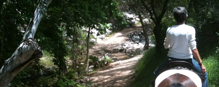
 Flint Canyon Trail runs through the Flintridge area, connecting Hahamongna Watershed Park in Pasadena on the east with the Cherry Canyon trails on the west. After passing under Oak Grove Drive and the 210 Freeway, the trail meanders through a lovely, undeveloped area with many oaks, sycamores, and a year-round stream before coming out next to Berkshire Avenue. It then drops down to Woodfield Road, a private street, where it continues along the street, then crosses Chula Senda Lane where the trail surface becomes soft surface again. Parts of the trail widen to 15 to 25 feet or more. These green open spaces add interest and variety to the trail experience.
Accessible from:
- Hahamongna Watershed Park
- Berkshire at Dover Road
- Woodfield Road
- Chula Senda west of Woodfield Road
- Woodfield Lane north of Berkshire Ave.
- Oakwood Ave. north of Berkshire Ave.
- Commonwealth Ave. north of Berkshire Ave
- Beulah Dr. north of Berkshire Ave.
- Berkshire Ave. west of Beulah Dr.
- Chevy Chase Drive north of Flintridge Ave.
- Hampstead Road – Cherry Canyon